Pitcairn History
Was George Washington Here?
.
By- Kurt Seibel - Pitcairn Historical Society
Did he pass through Pitcairn?
.
.
In October of 1770, there was one matter to which Washington felt was his duty as a soldier and a man of honor to devote his time and energies. A grant of two hundred thousand acres of western lands had been promised by the government to those who enlisted for the war against the French and Indians in 1754, but nothing was ever done to fulfill the promise. Washington undertook this act as an agent for his comrades. He, along with chosen friends and scouts, set off on a venture to explore possible sites for the bounty lands, making notes and observations as they journeyed to Fort Pitt, down the Ohio River and to the Great Kanawha River.
The following is documented by George Washington in his journal. (On his way westward towards the Ohio Country:
October 17th - Dr. Craik and myself, with Captain Crawford and others, arrived at Fort Pitt, distant from the Crossing forty-three and a half measured miles, dining at one Widow Miers, at Turtle Creek. In riding this distance we passed over a great deal of exceedingly fine land, (chiefly white-oak,) especially from Sewickley Creek to Turtle Creek, but the whole broken; resembling, (as I think all the lands in this country do,) the Loudoun lands for hills.
On his return eastward to Virginia 37 days later:
November 23rd - After settling with the Indians and people that attended me down the river, and defray the sundry expenses accruing at Pittsburgh,set off on my return home and after dining at the Widow Miers' on Turtle Creek reached Mr. John Stephenson (Scottsdale, PA) two or three hours in the Night.
The Miers's house was located in the vicinity of the former Turtle Creek High School on Sycamore Street and Monroeville Avenue in Turtle Creek Borough. Several large hills occupy the northern slopes of North Versailles just south of the Mier's house and with no known roads on that slope, which ascends about 450 feet to the ridge, it is unlikely that he traveled over the creek and up the large hill where the present day Greensburg Pike bridge crosses over Turtle Creek. Standing at that location today, one could imagine being there in 1770 with nothing in view but dense forest. Glancing across the creek towards the south at the large hill, you would logically assume that Washington instead traveled through the valley along Turtle Creek, through today's communities of Turtle Creek, Monroeville, Wilmerding, Pitcairn, and Trafford and reaching Brush Creek. With the hills not as steep past Brush Creek, he would have been able to travel with more ease in that area.
In 1770, only two roads existed from the Allegheny Mountains into Pittsburgh, Braddock's Road and Forbes Road. Braddock's Road allowed travel from the southeast from Virginia, through Fayette County and crossing over the Monongahela River twice near Duquesne, the crossing being just west of the mouth of Turtle Creek. Forbes Road permitted travel east through Ligonier, passing Bushy Run and Plum Borough to Fort Pitt. Seven years prior to Washington's visit was the Battle of Bushy Run. Colonel Henry Bouquet was forced to take an alternate route from Forbes Road at Bushy Run to pursue the Indians he had just defeated enroute to Fort Pitt. This alternate route went from Bushy Run to the mouth of Brush Creek at Turtle Creek (Trafford), through Pitcairn, then to the Mier's House in Turtle Creek Borough.
History tells us Bouquet discovered the Indian encampment at the outflow of Dirty Camp Run, a stream he named which flows into Turtle Creek from North Pitcairn. Being that Bouquet marched his army through Pitcairn after the battle, there must have been some remnants of a road cut through that area where he marched his troops.
.
It is also documented in the History of Western PA - By Israel Daniel Rupp that;
Prior to 1769, Aeneas Mackey, by permission of Lieut. Col. John Reid, made improvements at Dirty Camp, on Turtle creek, on the road from Fort Ligonier to Fort Pitt. John Frazier, John Ormsby, Sr & Jr, and Oliver Ormsby, had made improvements to Turtle creek prior to 1762, by permission from the commanding officer at Fort Pitt".
.
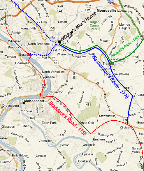
This alternate route would have given Washington an easier access route to and from his destination seven years later. Since Bouquet created (and Mackey made improvements to) an alternate route through present day Pitcairn along the northern side of the Turtle Creek, it is even more likely that George Washington traveled through the Pitcairn Borough limits, likely keeping to the northern side of Turtle Creek, since the Widow Mier's house was already on the northern side.
It is unlikely that George Washington followed Braddock's Road between Braddock, PA and Stewartsville for the following reasons:
.
1) On his return route, when he was at the Mier's House, he was already northeast about one and a half miles past the Monongahela River where Braddock's Road cut through the Monongahela River.
.
2) He would have had to cross the Monongahela twice, as did Braddock's Road.
.
3) On the day after his visit to the Mier's house on his return trip, Washington states in his journal that "When we came to the crossing at Crawfords (Connellsville at the Yough River) the river was too high to ford…" If the Yough river was too high to cross at that time, and was only crossable by canoe, then the Monongehela River would have definitely been too high the day before at Braddock, PA, which means Washington probably avoided the Monongehela River.
.
4) It would have been easier with an access road already being through the Turtle Creek Valley to Trafford (Bouquet's and Mackey's). He then would have traveled only a few miles along the Brush Creek Valley to Circleville or Stewartsville, most likely in the area of Skellytown Road where he would have linked back onto Braddock's Road at Clay Pike.
.
5) During Braddock's campaign, it was Braddock's intention to follow either the ridges (the direction of present day Rt. 30) or the valley (Brush and Turtle Creek) towards Fort Duquesne, but he was deterred by the hazards. As history has recorded in 1755:
.
"The crossing of Brush Creek, which he had now reached, appeared to be attended with so much hazard, that parties were sent to reconnoiter, some of whom advanced so far as to kill a French officer within a half mile of Fort Duquesne. Their examinations induced a great divergence to the left: (southwest) availing himself of the valley of Long Run (Lincoln Way), which he turned into, as is supposed, at Stewartsville(Norwin Towne Square area), passing by the place now known as Samson's mill, the army made one of the best marches of the campaign, and halted for the night at a favorable depression between that stream and Crooked Run, and about two miles from the Monongehela."(White Oak Borough)
.
6) Washington mentions in the October 17, 1770 entry of his journal, "exceedingly fine land, (chiefly white-oak,) especially from Sewickley Creek to Turtle Creek". Braddock's Road does not come close to Turtle Creek. The only time Turtle Creek is near Braddock's Road is at the northern crossing of the Monongehela, about one quarter mile past the mouth of the Turtle Creek, where it enters the Monongehela River.
.
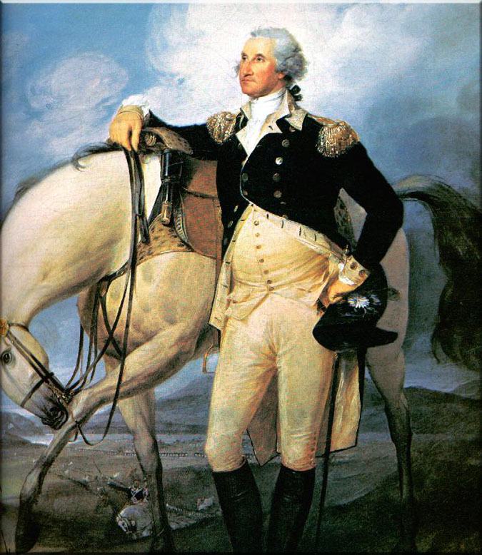
This being said, the assumption can be made that George Washington, age 38, traveled on horseback through the southern portion of what is now Pitcairn, PA during the afternoons of Wednesday, October 17, 1770 and Friday, November 23, 1770.
.
It's not certain, but it is most likely that "Washington Was Here……TWICE!"
Timeline
.
1763 – During the French and Indian War a band of Amerind warriors makes camp at a site just north of the Turtle Creek. After a skirmish, a victorious British expedition comes upon the hastily abandoned camp; its leader, Colonel Henry Bouquet describes the location in his journal as the “Dirty Camp.” The nearby stream is called “Dirty Camp Run.”
1769 – Aneas McKay, the first European settler in the area is granted a warrant of 300 acres of land known as the “Dirty Creek Tract.”
1770 – On his way to and from the Ohio Country, George Washington traveled through Pitcairn.
1789 – A second warrant of 300 acres is issued for the land just west of McKay’s Tract. Eventually becoming the ”McNair Tract,” this land, and its adjacent tract (later to be owned by Michael Wall), will eventually form the core of the towns of Pitcairn and Wall.
1835 – McKay’s Tract passes on to John McGinnis who plans to establish a town along the Turtle Creek.
1841 – John McGinnis begins selling lots at the crossroads of Tilbrook and the Great State Road (today’s Route 130); a place he called “McGinnisville.”
1850 – The Pennsylvania Railroad (PRR) buys a right-of-way 66 feet wide from John McGinnis.
1851 – The PRR begins east-west train service from Philadelphia to
1863 - During the Civil War, an artillery firing range was set up on the north bank of the Turtle Creek just east of the present-day Mosside Bridge as a proving ground for cannons then being forged at the Fort Pitt Foundry in Pittsburgh.
1880 – At the urging of the railroad’s Superintendent, of the Pittsburgh Division, Robert Pitcairn, the PRR begins construction of the Pitcairn Yard on 215 acres of farmland along the Turtle Creek Valley in the vicinity of the Wall Station
1890 - The village growing up in the vicinity of the Railroad yards becomes known as “Walurbia” -- meaning a suburb of Wall.
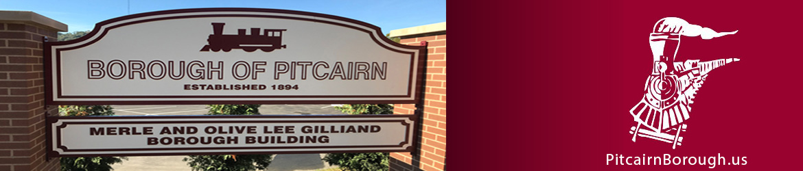
1894 – The village incorporates as a Borough and adopts name of the Railroad Superintendent, “Pitcairn.” The first Borough Council is elected; Norris Cameron, M.D., is elected as the first Burgess.
1896 – The Borough builds its first school house (School House #1 on Sixth Street)
1897 – At the request of the Borough council, the PRR changes the name of its depot from Walurbia to Pitcairn.
1898 – Because of a lack of service by local electric companies, the Pitcairn Council floats a bond to finance its own electric plant and distribution system.
1901 – The Pittsburgh and Wilmerding Street Railway Company runs a trolley service along Broadway with a fare to Pittsburgh of 15 cents.
1903 – The new Borough Building is dedicated.
1904 – Broadway, Second and Third Streets are paved; a bridge is built over Dirty Camp Run.
1906 – The first Nickelodeon theater opens on Broadway.
1916 – The Pitcairn High School is dedicated.
1923 – North Pitcairn is annexed
1925 – Household mail delivery begins.
1951 – Pitcairn acquires Sugar Camp to use as a community park.
1955 – The schools of Monroeville and Pitcairn form the Monroeville-Pitcairn joint Schools. In 1960 the jointure is re-designated as the Gateway Union School District; in 1965 -- the Gateway School District.
1959 – The PRR gives the newly-renovated YMCA Pitcairn Community Building to the Borough.
1970 – Pitcairn becomes part of the Turtle Creek Valley’s “Model Cities” program.
1975 – The Pitcairn Park Building is dedicated, and plans made for a parks system.
1982 – Pitcairn gains 38 acres in the area around the Park Building and Sugar Camp in the north through land annexation from Monroeville.
.
Source - Monroeville Historical Society